Links
Short History of Pomerania: ContentDiese Seite auf Deutsch: Die Frühgeschichte und Christianisierung von Pommern
Pomeranian_Griffin: The Worldwide Pomeranian Internet Group
The name "Pomerania" (Pommern in German) originates from the Slavic expression "po morje" ("po morze"), which means as much as "on the sea". Sources already attest to the use of the name Pomerania for the areas east and west of the Oder River and for the central area at the mouth of the Oder as early as the middle of the 12th century. The first mention of the name is made in the annals of the Bavarian Benedictine monastery at Altaich, which were compiled after 1050: Together with the Dukes of Poland and Bohemia, Duke Zemuzil of Pomerania ("dux Bomeraniorum") rendered homage to the German King Henry III of, who had previously settled disputes among the Slavic Lords.
Pomerania, the territory on the sea, stretches from the Darss peninsula in the West to Lake Zarnowitz in the East all along the shore of the Baltic sea ("Mare Balticum") in a 50-60 km wide band. When looking at a map of Pomerania, its shape seems to embrace or reach out to the sea. It is therefore to be expected that whoever dominated the Baltic Sea, would also tend to dominate the developments within Pomerania. Measured from east to west, Pomerania extends for 370 km, with the shoreline having a true length of 465 km. The territory is divided by the Oder River. To the east of the Oder, the coast is gentle without any natural harbors. But to the west, the shore is jagged and torn, favoring the development of harbor cities such as Stettin, Stralsund, Greifswald and Anklam during the Middle Ages. In the text that follows, Hither and Further Pomerania (Vor- and Hinterpommern) will be used to describe the areas west and east of the Oder respectively, even for periods when these terms were not actually used. - The southern belt of Further Pomerania is part of an ancient terminal moraine called the Baltic Ridge, and is associated with poor soils with limited use for agriculture. The most fertile soils occur around Stettin and Pyritz where they form an area know as the Pyritz wheat belt (Pyritzer Weizacker). Fertile soils also occur widely in Hither Pomerania, on the island of Ruegen and in the Further Pomeranian coastal plain.
The area described above had been inhabited by Germanic tribes for many centuries. In the 6th and 7th centuries, Slavic tribes started moving into the area from the area of the Elbe and North Sea Coast (referred to as the Northwest Slavs). They intermingled with the remnants of the earlier Germanic population and established clans such as the Wilzians and from the 10th century on the Lutizians in the West, the Ranians on Ruegen and the Pomoranians (those by the sea) in the East, which included the Pyritzians. The territory of the Pomoranians was bounded by the Oder River in the West, the Weichsel River in the East and the Netze and Warthe rivers in the South. Their lord, Duke Zemuzil, as mentioned above, is documented for the year 1046.
The Slavic tribes and clans established forts for their protection as well as administrative centers, both of which expanded to become trading and manufacturing centers from about the middle of the 10th century. The core area at the mouth of the Oder was under the control of the Slavic-Viking trading center of Jumme, Jumne, Julin or Wollin for many centuries. This was the mythical Vineta and the Jomsborg of the Vikings, who conquered and pillaged Wollin approximately 15 times, including the Danes under King Magnus the Good in 1043.
The larger towns had their markets where goods from as far afield as Russia, the Byzantine Empire and Arabia were traded. The Slavs preferred to live in small villages. They engaged in livestock farming, fishing and plunder, and to some degree also in agriculture. They made extensive use of the two-year crop rotation system using a hoe as their main farming implement. The fields were located in forest clearings or in the middle of meadows, rather than locating all the fields together in a farm. The farmers were dependent on the nobles to whom they owed tributes and labor just as they owed these to the sovereign. The people adhered to a poly-demonic religion, which lasted well into the 14th century on the island of Rügen and survived as long as the old extensive farming method was practiced. Apart from the Vikings, these areas also came under pressure from Germans and Poles. The Poles overthrew the Pomoranians towards the end of the 10th century. They established a suffragan bishopric of Gnesen at Kolberg in 1000 AD thereby extending their sphere of influence over this area for a short period.
At the beginning of the 12th century, Stettin with its population of a few hundred families or 5000 individuals had become the most important center. The political center of gravity therefore shifted westwards from the area around Kolberg to the mouth of the Oder. The territory that was under the command of Stettin stretched from the Demmin-Wolgast line in the west all the way to Gollenberg east of Koeslin. The ruler of this area in the first half of the 12th century was Wartislaw I. He is the first known representative of the original Slav dynasty, which adopted the name of the griffin (Greif in German), their heraldic beast, in the second half of the 15th Century. The Greif dynasty ruled Pomerania for 16 generations despite many divisions of the Pomeranian lands. One cannot really speak of a well-defined territory as early as the 12th century, nor even of a formally ordered state. Wartislaw I. was murdered around 1147/48, possibly by his heathen foes. To the east of Pomerania-Stettin (also known as "Slavia", "Cassubia" or "ducatus Stettinensis et Dimminensis") another authority established itself roughly at the same time in an area later known as the districts of Schlawe-Stolp, which extended from Gollenberg to the Leba river. The ruler of this territory was Ratibor I, brother and successor of Wartislaw I (he died around 1156). His dynasty lasted until 1227 and was known as the Ratiborides.
The most eastern part of the Pomoranian lands mostly belonged to Poland during the 11th century. It developed quite separately from the rest of Pomerania and was generally referred to as the Dukedom of Pomerania-Danzig or as 'Pomerelia'. It extended from the Leba River to the Weichsel. It was governed by the Samboride dynasty (related to both the Polish Piasts and the Pomeranian Greifs) until the last male heir died in 1294. Because of its separate development, Pomerania-Danzig will not be discussed further in this article.
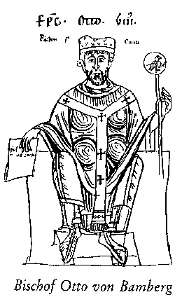
In 1121/22 the Poles under Duke Boleslaw III "Skew mouth" conquered Stettin and Wartislaw I was subjugated. At the same time he extended his own territory to the Mueritz and Peene rivers, either in agreement with or on order of his Polish lord. During his subjugation under the Polish Duke, Wartislaw I agreed to open his lands for Christianisation. The Polish clerics did not establish a strong missionary activity in Pomerania-Stettin and the Polish Duke therefore called Bishop Otto von Bamberg (who died on 30 June 1139), a Swabian nobleman whom he had met on his earlier visits to Poland, to lead the Christian mission to Pomerania. The bishop, who is referred to as the apostle of the Pomeranians, embarked on his first mission in 1124. The visit was well organized and permission had more or less been granted by all the relevant rulers. He traveled via Prague, Breslau and Gnesen and visited Pyritz, Kammin, Wollin, Stettin, Garz (on Usedom ?), Lebbin, Cloden, Kolberg and Belgard an der Persante, among others. He preached and baptized Wartislaw I and a large part of the population within the year of 1124. Otto von Bamberg undertook a second mission in 1129 after heathen uprisings occurred, most likely the result of the Duke's westward expansion. After consultation with King Lothar III of Supplinburg (1125-1137) this visit started off in Merseburg with a first stop at Magdeburg, where the Archbishop was taken into confidence. During that same year, the lords of the newly won areas in the West accepted the Christian faith at Usedom as a result of Otto's efforts. - Wollin was earmarked as the seat of the bishop. But no agreement was reached on whether this bishopric, which extended to the Leba river in the East, would become part of the Magdeburg or part of the Gnesen church province. The establishment of this bishopric, with the seat in Wollin, was therefore delayed until 1140 but neither Magdeburg nor Gnesen withdrew its demands. - The bishop relocated to Usedom in 1170 after Wollin had again been thoroughly destroyed by the Danes and then moved the seat to Kammin where a cathedral chapter was established the same year. In 1176 the bishopric of Kammin was granted the right to freely choose its bishop and the members of the cathedral chapter. In 1188 it was granted exemption, i.e. it reported directly to Rome, as may have been the original plan in 1140.
After the conversion to Christianity, monasteries were established in the fertile areas in Pomerania described above. These were: the Benedictene monastery in Stolpe an der Peene (1153), inhabited by monks from Magdeburg, the Premonstratensian monasteries Grobe on the island of Usedom (1156, from 1309: Pudagla) and Belbuck close to Treptow an der Rega (1178) as well as the Cistertian monasteries Dargun (1172), which later fell to Magdeburg, and Kolbatz (1173), which was founded from Esrom in Denmark. Mention must be made of the Benedictene Priory of St Jakob in Stettin, a subsidiary of the Michelsberg monastery at Bamberg. The convents and monasteries of the 12th Century were initially inhabited by Danish nuns and monks rather than German ones. The Germans only took over in the 13th century. - In this connection the establishments of the large knightly orders must be mentioned too. The Knights of the Order of the Hospital of Saint John of Jerusalem (The Knights of St. John or 'Johanniter' in German) can be traced back to 1160 in Schlawe and the area around Kolberg and they may also have founded Burg Stargard (Alt Stargard, Preussisch Stargard an der Ferse) at the end of the 12th century. Tempelberg reminds us of the Knights Templar, an order that was dissolved in 1312 and whose possessions fell to the Knights of St John. This town first became part of Poland and then fell to Brandenburg in 1657. The territories of Bahn and Kuestrin were conferred on the Templars in 1234.
Next Chapter: 2. Pomerania
between Poland, Denmark, Saxony and Brandenburg (1135-1194)